Felbridge Then & Now
Please be patient whilst the pictures download. The Felbridge archive contains over 2000 indexed entries consisting of photographs, newspaper clippings, postcards, copy deeds and memories. There is also a large collection of local census records, maps and copy parish records. The archive may be searched by appointment.
Please acknowledge our group if using any of this material.
This is a preview of our book 'Felbridge Then and Now' that contains 26 old photographs matched with the same view today. The text is abridged for the web page.
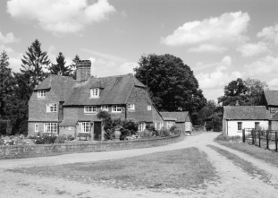
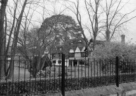
Hophurst Farm c1938 |
|
| Situated to the South of Felbridge, Hophurst stands on one of the ancient Ridge Ways that crossed the Weald. It was once part of the Manor of South-Malling and was known as Hoppers, and it is believed to have taken its name from the Hopper family who once occupied the area. By 1590, Hoppers was occupied by the Alfrey family, relatives of the medieval MP for East Grinstead. Later owners include members of the Shelley family between 1814 and 1865. | 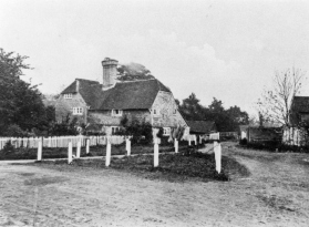 |
| There is evidence that there has been settlement in the Hophurst area since the 13th century, however, the current property dates from the early 16th century, with the earliest part to the Right of the chimney stack. The chimney, built between 1550 and 1600, replaced the smoke bay of the original building. At the same time as the chimney, a crosswing was added. The original house was timber framed, built on stone and infilled with wattle and daub. (picture donated by M Becker) |
 |
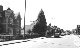
North End c1905 |
|
| Although North End, as its name suggests, is located at the extreme North of East Grinstead, it has been part of the ecclesiastical parish of Felbridge since 1865. This area was part of East Grinstead Common that once stretched from the Macdonald's area in East Grinstead to the stream on the Surrey/Sussex border in Felbridge, and from Lowdells Lane to Imberhorne Lane. | 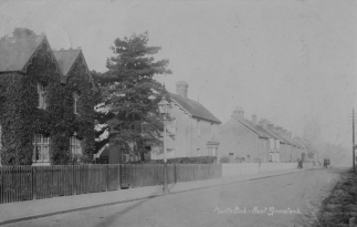 |
| North End was developed from the mid 1800s onwards and included housing, a school, laundry, bakery, brewery and shop, making it a small community in its own right. The scene from 1905 remains relatively unchanged to this day, apart from the volume of traffic. The pair of houses on the extreme left of the picture have had their creeper removed along with the tree in their front garden. A more recent tree, in the next plot, now obscures the property that was, and still is, the shop. (Photograph by EG Photography Ltd) |
 |
Newchapel c1910 |
|
| Situated to the West of the main London road at Newchapel Corner. This view was taken looking North West from the main road. The farm, dating from the Elizabethan period, was originally called Chapel Farm, being known as Newchapel Farm by the 18th century. During the mid 1700s it was also known as The Evelyn Arms, taking its name from the Evelyn family that had bought land at Felbridge Heath and the manor of Hedgecourt to create the Felbridge Place estate. | 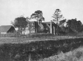 |
| The name would also imply that at this time it was probably in use as a coaching inn, being on the main London to Brighton route. After the sale of Felbridge Place estate in 1911, the farmhouse underwent a complete transformation, and became known as Newchapel House, the old house still being at the centre of a much extended property. (picture donated by P Bateman) |
 |
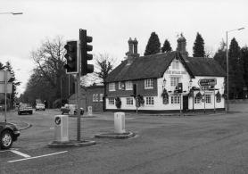
Star Inn c1911 |
|
| Situated on the Surrey/Sussex border, the Star Inn had been built on this junction by 1748. The Inn takes its name Star from the emblem on the badge of the Earls of Surrey and Sussex, quite appropriate considering its location. It was built as a coaching inn, being a convenient one-days ride from London and the coast. The original part of the building runs along the Copthorne Road, being later extended during the 19th century. | 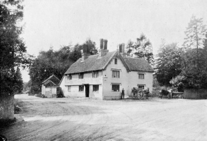 |
| Stabling and a coach house were located behind the inn. The inn was once part of the Felbridge Place estate and operated under a six-day licence, with a closing time of 9 oclock, until 1912 when closing time was extended to 10 oclock. Sunday opening was not thought to be appropriate by the vicar at that time, so seven-day opening had to wait! (picture donated by F Wheeler) |
 |
Rowplatt Lane c1930 |
|
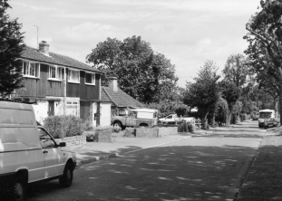
| This view of Rowplatt Lane, looking North, is another photograph in the series of local postcards produced for C Wheeler, whose stores can be seen on the left in this picture. In 1912, Mr and Mrs Pattenden bought Nos. 1 to 4 Rowplatt Lane, including the land where The Ark now stands. At that time there were no other buildings in the lane, being only a cart track with a corn field on the West side and Warren House Farm on the East. | 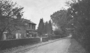 |
| In 1925, their daughter and son-in-law, Dora and Charles Wheeler, opened their shop, operating from No. 4. They ran the business until 1949, when it was sold to C J Smith, then passing to D Smith and finally Mr and Mrs Shoubridge. In 1964, the small row of cottages, including the shop, were demolished, replaced by three modern houses. Rowplatt Lane takes its name from the making of rope, (rope plait), produced here in the 18th century. The rope yard was situated on the site of Lyric Cottage, and the road is exactly a ¼ mile long, the length of a rope walk. (picture by Wheeler) |
 |
Please contact us if you have images of people or places in Felbridge.