Archaeological Field Walks in Felbridge
The history group held its first field walk in May 2003 at Imberhorne Farm. It was a fine day and over 60 people turned out to help, the vast majority never having carried out any archaeological activity before. The walk covered the northern part of Long Field, Imberhorne Farm alongside the Gullege track from Crawley Down Road. The picture below was taken on the day.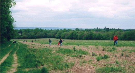
View of Long Field looking North with walkers coming up the field
Imberhorne Farm Archaeological Field Walk Report of 10th May 2003
Brief Summary of events
Members of the Felbridge & District History Group and students of Imberhorne School, with the help of several volunteers, under the direction of amateur archaeologist Martin Bastone, carried out the field walk at Long field, Imberhorne Farm, East Grinstead, to establish evidence of any archaeological activities within the bounds of the farm. The resulting finds confirmed that the area has seen human activity from the Mesolithic period through to the modern day with particular concentrations relating to the medieval period and 15th to 16th century.
Introduction
Imberhorne Farm (TQ3724 3840) encompasses the demesne lands of the manor of Imberhorne dating to about 1100, and Gullege (TQ3654 3841), the freehold property of the Alfrey family from c1300, situated at the northern end of the manor of Broadhurst. The limited archaeological research that had been carried out suggested prehistoric activity and medieval settlement in the field west of Gullege Lane, based on the presence of worked flints and localised domestic finds. The field walk, the first of a planned programme of field walking, was undertaken with the landowners permission and full support to record any archaeological information in an attempt to address the almost complete lack of archaeological research of the area and to gain an understanding of the land use. The walk was made possible through donations made by Brian and Marilyn Emmett, Laura Sansom, Stephonie and Jeremy Clarke and the East Grinstead Society.
The field covered by this report is called Long Field being in excess of 50 acres and with the resources available, the decision was taken to walk only the northern half of the field. The field itself is L shaped, the widest section at the southern end, then running between trees on the east of the field and tree lined Gullege Lane, heading towards the Felbridge Water at the northern end.
Long Field is made up of a strip of what had been five fields in 1842, being part of Gulledge Farm, in the manor of Broadhurst, with the addition of one field to the southeast, once part of the demesne lands of the manor of Imberhorne. The purchase of Gulledge Farm in the late 19th century by Sir Edward Blount, then owner of Imberhorne Farm, joined the lands of the manors of Broadhurst and Imberhorne, and although the house at Gullege was later sold off, the lands of Gullege remain part of Imberhorne Farm.
From the East Grinstead Tithe of 1842 we can identify the names of the five fields that belonged to Gullege, heading from the house known as Gullege to the stream, they were Kitchen Garden Field, Mole Forest, Upper Rail Field, Lower Rail Field and Grub Copse. The name of the latter field implies that at some time before 1842 this section had been wooded. The field that has been incorporated from what was Imberhorne Farm to create the L shape of Long Field as it is known today, was called Long Ten Acres. This field adjoins Kitchen Garden Field and Mole Forest, and over the years all the hedgerows have been removed to create a single field of approximately 53 acres.
Gullege Lane, the trackway running north/south to the west of Long Field is believed to be either on, or very close to, the route of the Whapple Way referred to in a survey of the Bounders of the Hundreds of the Duchy of Lancaster in the Rape of Pevensey (1579). Map evidence suggests that until the mid 19th century there were at least two buildings in the field to the west of Gullege Lane, and another building to the south of Gullege, making this area a small hamlet and not the isolated house that it is today.
The full report including photographs of specific finds is below as a PDF file, you will need Acrobat Reader to view the report.
![]() field_walk_report.pdf (679kB)
field_walk_report.pdf (679kB)
There have been many field walks and small excavations since and these are covered by the following report.![]() archaeology_of_imberhorne_farm.pdf (826kB)
archaeology_of_imberhorne_farm.pdf (826kB)
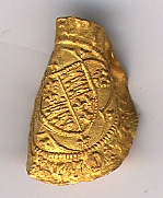
Below is one of the best finds from the fields. It is a Gold Quarter Ryal 1466/7 found by Ron Payne of the West Kent Detector Club in 2008. Unfortunately it has been struck by a plough.